NISAR Opens a New Window on Earth. Amateur Radio Operators Can Benefit Too.
Date :
31 /
07 /
2026
Author :
NASA
The joint NASA-ISRO Synthetic Aperture Radar (NISAR) mission has reached another significant milestone, with the public release of data from its powerful L-band and S-band radar instruments. Scientists, researchers and anyone with an interest in Earth observation can now access an ever-growing archive of radar imagery capable of revealing subtle changes to our planet's surface, from moving glaciers and sinking cities to forests, wetlands and earthquake damage.
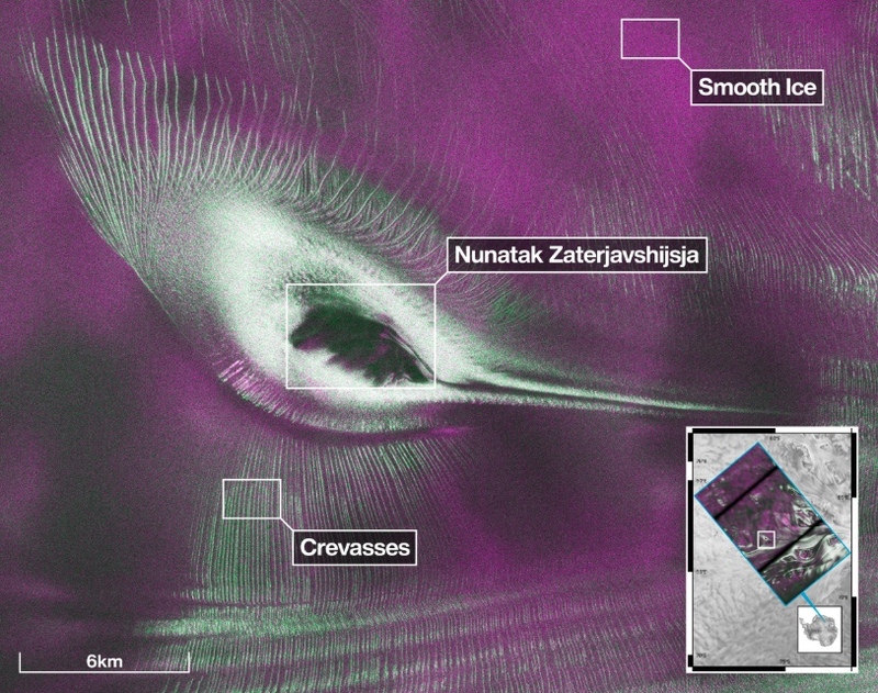
Unlike conventional optical satellites, NISAR uses Synthetic Aperture Radar (SAR), allowing it to image the Earth's surface day and night and through cloud cover. Orbiting the Earth every 12 days, the satellite systematically maps almost every land and ice-covered surface on the planet using two complementary radar frequencies. One of the first publicly released images has already captured worldwide attention, revealing what appears to be a giant hummingbird hidden within the fractured Antarctic ice. In reality, the spectacular image shows glacier ice flowing around a mountain peak, demonstrating both the scientific power and unexpected beauty of radar imaging.
For Australian amateur radio operators, NISAR represents more than another impressive space mission. Radar and radio have always shared common roots, and many of the same principles used in amateur radio, including antenna design, microwave engineering, digital signal processing and propagation, underpin spaceborne radar systems. NISAR's L-band radar operates at approximately 1.26 GHz, only a short distance below the amateur 23-centimetre band, while its S-band radar operates around 3.2 GHz, between our 13 cm and 9 cm allocations. Although the mission operates well outside amateur allocations and uses highly specialised equipment, it provides a fascinating real-world example of how radio frequency engineering is solving global scientific challenges.
The freely available datasets also offer opportunities for citizen scientists, universities and technically minded amateurs interested in remote sensing, image processing and geospatial analysis. As software-defined radio and open-source signal processing continue to grow in popularity, projects such as NISAR demonstrate how radio technology extends far beyond making contacts on the HF bands.
Meanwhile, India's rapidly expanding space sector has celebrated another milestone with Skyroot Aerospace successfully testing its Vikram-1 launch vehicle. The test marks another important step for India's first private orbital launch company and highlights the country's growing capability to place small satellites into space. With more satellites comes more opportunity for radio amateurs to track, receive telemetry and, in some cases, communicate through amateur payloads in the years ahead.
Website: Link
Page Last Updated: Friday, 31 Jul 2026 at 07:55 hours by Justin Giles-clark
Click Here To Return To Previous Page
|